After a very quiet start to May, the atmosphere changed. The central United States erupted unexpectedly this weekend. Intense tornadoes, giant hail, and extremely dangerous winds were recorded.
The meteorological threat is set to reach its peak on Monday. The day could bring the most dangerous round of severe storms. The volatile phenomenon has been developing unchecked in the Plains.
This severe weather outbreak is expected to last at least until Tuesday. It will bring the latent risk of intense EF3 category tornadoes. There will also be destructive hail, damaging winds, and torrential rains in the region.
What Caused This Drastic Change?
May is globally known for severe thunderstorm outbreaks. The Plains and Midwest regions suffer from these phenomena. This year, the month appeared to have started unusually quiet.
That initial calm was due to a jet stream pattern. This climate phenomenon had suppressed severe storms until now. However, that same pattern is setting the stage for destructive events.
Storms began developing rapidly Sunday afternoon. The phenomenon advanced aggressively from Kansas to Nebraska. It even reached southern Minnesota with hail larger than a baseball.
What Damage Was Reported?
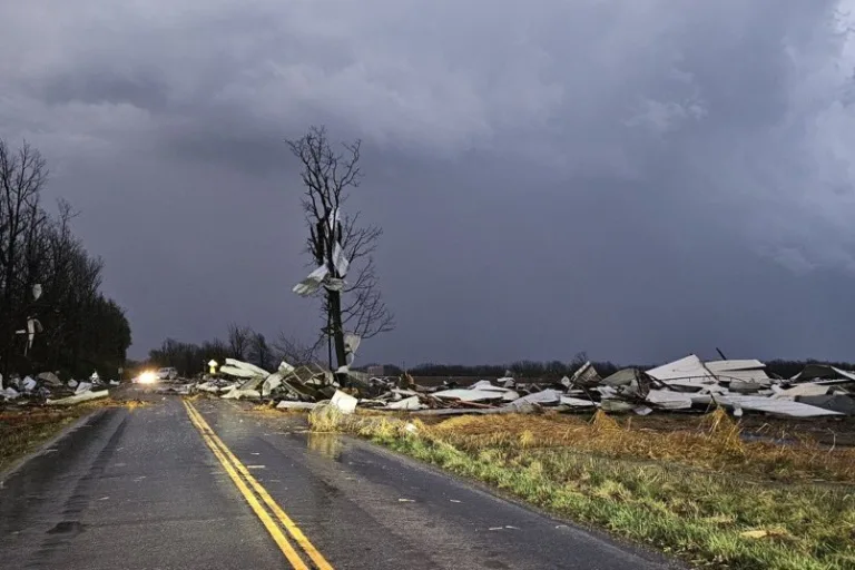
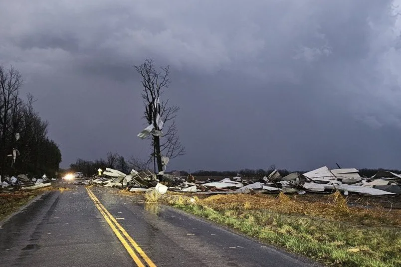
A level 3 out of 5 severe storm threat spread rapidly. It covered much of the productive heartland of the United States. More than a dozen tornado reports were recorded Sunday.
In addition to this were more than 100 reports of hail and strong winds. The vast majority occurred in eastern Nebraska and western Iowa. The National Weather Service confirmed a strong tornado in Grand Island.
The impact occurred specifically in the small town of St. Libory in Nebraska. Several residential and commercial structures were severely damaged by wind. Video captured the tense rescue of two people from a basement.
Why Was an Emergency Declared?
Sunday night a tornado emergency was issued for the region. It is the most significant and severe type of weather warning. It was activated for a large storm located very close to Hebron, Nebraska.

Fenómeno “Omega” traerá calor extremo y lluvias a USA
El patrón Omega bloquea el clima en Estados Unidos y deja calor extremo, lluvias y...
Emiten rara alerta de tornados en el centro de Estados Unidos
El centro de Estados Unidos enfrenta una rara alerta por tornados severos y granizo gigante,...
This area is located just over 16 kilometers north of Kansas. Tornado emergencies are only issued under very specific conditions. Meteorologists must be certain that a destructive tornado is approaching.
At least one house was completely destroyed by the phenomenon. However, no injuries were reported by Sunday night. This was confirmed by the Emergency Management Director of Thayer County.
What Is the Overnight Risk?
Shortly before midnight Sunday, the meteorological situation deteriorated considerably. Isolated storms consolidated into a massive derecho line. This made damaging winds the primary concern for authorities.
Wind gusts could exceed 75 miles per hour at times. This force is sufficient to knock down trees, poles, and damage roofs. Some short-lived tornadoes could still form along the leading edge.
A widespread outbreak of severe storms could occur very soon. This will happen when the energy of the jet stream interacts violently. It will find abundant amounts of moisture accumulated in the Plains region.

Desarrollador de Software
12 años de experiencia